《GNSS技術藍皮書》研究發現三大技術趨勢和三個要點(亮點、熱點和焦點)。其中,GNSS接收機系統蛻變創新技術成為焦點,這是為什么?“上面千條線,下邊一根針”,這就是說,GNSS千變萬化,最終匯聚到一點,就是接收機系統技術蛻變創新這個核心焦點上,因為GNSS服務的實現最后都由接收機系統加以體現,無法逾越,不可或缺,但是隨著GNSS系統變革和應用服務面向對象的更迭,其蛻變創新也是最大的。GNSS接收機系統是GNSS系統和技術與產業的對接點,也是三大技術發展趨勢和三個要點的交匯點,還是當前GNSS系統與產業轉折性發展的著力點。
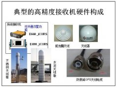
通常,大家一談起GNSS接收機,談的最多的就是芯片,或者芯片組。講芯片功能多么強大,工藝多么高。這些當然很重要,但是接收機作為一個系統,不僅僅在于芯片本身,而是還與輸入端的天線,和輸出端的應用服務接口與配套設施密切相關,還與多種多樣的定位算法和軟件組密切相關,也就是說與接收機系統,尤其是結合應用服務的不斷與時俱進的技術創新密切相關。
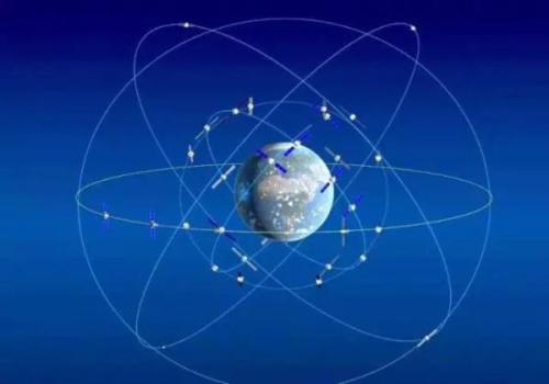
當前,GNSS接收機系統創新技術成為焦點,主要體現三個方面:一是GNSS信號體制的全方位創新帶來的革命性變化,GPS和GLONASS現代化,極其重要的現代化舉措是信號體制的更新變革,GPSIII采用的新信號,和GLONASS采用CDMA與FDMA共用體制,北斗三號和伽利略系統采用的新信號體制,尤其是GNSS兼容互操作,利用兩個共用頻點,實現多星座信號雙頻高精度服務,將GNSS應用服務水平和經濟實用性,提高到一個嶄新的層級,其巨大效應還剛剛出現曙光;二是隨著GNSS應用服務領域的廣泛深入,與其它技術和系統的跨界融合,特別是通信導航的相互融合,GNSS接收機系統的形態在發生根本性的變化,如在移動手機中,GNSS接收機往往不是以獨立的專用導航芯片方式出現,而是作為移動手機RF頻率配置和基帶的一部分,用軟硬件結合的IP方式將導航功能加以實現,在不久將來,說不定會依托通用器件用軟件接收機方式加以實現。在車聯網、船聯網、物聯網應用中有可能會創造豐富多彩的接收機形態;三是在泛在的新時空服務中,GNSS只是堅強PNT的組成部分之一加以應用,它與聲光電磁和機械慣性等時空信息提供者在一起,體現泛在、精準、安全和連接的基礎性能,形成自動化和智能環境感知技術,構成智能信息時代賴于生存發展的生態系統的基礎,推進無人機、無人車、無人船等無人系統的發展進步,推進智能信息產業的快速、健康、持續發展,在新技術新產業革命的鳳凰涅盤中獲得重生。
在GNSS系統和產業的發展中,現在進入了一個轉折性的發展歷程,這就是由系統建設階段,轉變為產業發展階段,這就是通常說的,從以技術引領為主的“北斗+”時期,進入以市場帶動為主的“+北斗”時期,導入了一個新的產業發展時期。北斗的應用服務產業,業已到了一個從量變到質變的嶄新的發展期,高精度大眾化應用技術的創新,將北斗/GNSS產業提高到一個前所未有的新高度,而“+北斗”將產業深化發展,與各行各業的深度融合,創造出千姿百態、千變萬化的GNSS接收機系統技術,這種蛻變創新,會持續很長很長時間,經久不衰,創造出層出不窮的新應用新服務,造福全中國全世界。
近期,GPS World 對知名專家學者2019全球衛星導航行系統發展趨勢預測進行了梳理匯總,亮點頗多,不容錯過。全球定位系統處主任史蒂夫·惠特尼(Steve Whitney)上校指出:要通過GPS企業集成發展路線圖,著力發展ERTL、ERM及ERM-M-代碼三方面的能力。 ERTL主要聚焦于整合一系列頂尖資源,如新的衛星、新的地面系統和新的發射提供者,安全地將航天器送入預設軌道,并對其進行有效控制;ERM的目標為將GPS III衛星帶入活躍的星座,提供類似于當今星座系統的服務功能;ERM-M-代碼側重軍用,主要為戰士提供更強大、更具靈活性、抗干擾/防篡改的PNT信號能力。
歐洲空間局Galileo項目計劃部主任Javier Benedicto指出:自2016年12月宣布初始服務以來,歐洲航天局(ESA)和歐洲全球衛星導航局(GSA)一直致力于伽利略系統能力和服務魯棒性的建設。2019年初, Galileo的工作衛星將多達22顆。在星載軟件升級并可為用戶提供自動健康狀態標記后,衛星橢圓軌道上增加的兩顆FOC衛星會加入運行星座,屆時將有24顆伽利略衛星為全球用戶提供PNT服務支持。此外,歐空局已為第一批“過渡衛星”啟動了競爭性采購程序,其中考慮到了廣域增強及一些其他的新功能,包括改進的信號域、更快的信號采集能力、更低的接收器功耗、星載時鐘技術、星間鏈路、電力推進、靈活的有效載荷,以及通過機載數字技術和在軌重構實現的功率分配。
北斗衛星導航系統總設計師楊長風院士總結說:2018年北斗在系統建設、系統集成和國際發展等領域取得了豐碩成果。北斗二代系統性能得到了很大提升,北斗三代星座部署基本完成,并集成了前兩代北斗系統的短報文通信功能,短報文信息容量可達原來的10倍。2019年至2020年間,北斗將繼續努力提升服務的持續性、穩定性和準確性,并通過發射另外6顆MEO衛星、3顆IGSO衛星及2顆GEO衛星推進北斗三代衛星的部署, 實現2020年為全球用戶提供導航、定位、授時、短報文通信及搜救等服務的目標。
俄羅斯航天系統公司主管Yury Urlichich認為:2019年將為GLONASS用戶帶來許多新的機遇。通過用戶層面信號的準確性和可用性方面的評估獲取改善的導航服務能力是2019年的首要目標。Glonass-K2計劃于2019年發射。與Glonass-M和Glonass-K衛星相比,Glonass-K2的任務要求將用戶測距誤差定義為0.3米。提升導航精度主要借助空間系統的發展,包括軌道星座(空間部分)和地面控制部分,由此實現GLONASS用戶性能的改善。
現將GNSS 2019發展趨勢預測原文轉發如下,以饗業內同仁及廣大讀者。如果您對北斗衛星導航系統及產業發展有任何意見或建議,歡迎留言或直接與我們聯系。
正文:
Integrating the Enterprise
BY Col. Steven Whitney DIRECTOR, GLOBAL POSITIONING SYSTEMS DIRECTORATE
Navigating across the world’s roads with GPS is easy. Navigating through the shifting construction zones, detours, and forks of the GPS Enterprise is not always so straightforward. For that reason, the GPS Directorate has placed more emphasis on illustrating, both figuratively and literally, the roadmaps leading to the integration of the GPS Enterprise. Before linking everything together, let’s start with an update on each major program effort. This way you can zoom out to see the path ahead; hopefully minimizing any “route recalculating” along the way.
Program Updates
The journey to build the new GPS III satellites has been full of twists and turns but we are now close to our destination – in this case the GPS orbit of 12,550 miles above the Earth. We not only have ten GPS III Space Vehicles simultaneously in production at Lockheed Martin’s manufacturing facility in Waterton, Colorado, but are also going full swing on preparations to launch our first vehicle in December 2018 on a SpaceX Falcon 9 rocket – more on this later. The GPS III satellites provide signals designed to improve the user’s ability to navigate. In addition to the increased power and greater accuracy, GPS III adds a civil new signal, L1C, designed for compatibility with the international Global Navigation Satellite Systems (GNSS) community.
GPS IIIF. In September 2018, the Air Force awarded the GPS III Follow-on contract to Lockheed Martin. This $7.2B contract for 22 satellites was the result of a competitive process for a production effort. Based on the GPS III technical baseline, the GPS IIIF family of satellites embraces modernization and capability improvements in multiple areas. First, a Regional Military Protection capability will provide increased anti-jam capabilities. Furthermore, a new Search-and-Rescue (SAR/ GPS) payload will provide improved timeliness of global search-and-rescue operations. Additionally, a Laser Retro- reflector Array (LRA) payload will enable precise ranging measurements and the program will implement a Unified S-Band capability to address consolidation of telemetry, tracking, and commanding frequencies. Finally, the program will host a redesigned Nuclear Detonation ( NUDET) Detection System (NDS) solution that has a lower overall size and weight. We look forward to the continued partnership with Lockheed Martin and will be looking collaboratively at opportunities to add additional capabilities incrementally over the life of the 22 GPS IIIF satellite production line.
OCX, the Next Generation Operational Control Segment. Last year Raytheon delivered the initial system, known as OCX Block 0, to support the launch and on-orbit check-out of the GPS III satellites. This past year, we have actively utilized the system in a variety of exercises, training events, compatibility tests, and launch readiness events. We also completed a comprehensive security review of the system to demonstrate our readiness to start operations. The system is ready to go. We continue to work the development of the OCX Block 1 system and are wrapping up the initial coding of the system early in 2019, leading into our integration and test campaign. The journey over the past few years has been challenging, but we have emerged stronger, armed with better metrics, and a culture of integrated development (often called DevOps) which puts us on a path to success. There will be challenges and risks in the path ahead but rather than mountains to climb, I see these more as standard blocking and tackling of a software intensive program.
Legacy Ground Sustainment. Running in parallel to these modernization efforts is the all-important work to sustain our existing GPS infrastructure of our current Operational Control System (OCS). These sustainment efforts ensure GPS continues to be the gold standard in positioning, navigation, and timing but also are a crucial “on-ramp” to facilitate a smooth merge onto the modernized GPS capabilities. Since 2014, the GPS program office has incrementally implemented several upgrades that not only maintain our satellite constellation delivery of GPS signal-in-space accuracy of 50 cm, but also significantly increases the cybersecurity posture of the legacy OCS. These upgrades culminated with a deployment of the latest modification in October 2018, which finished a worldwide modernization of our entire control system hardware and software. This latest upgrade, known as Version 7.5, virtualized the network, implemented two-factor authentication, and improved encryption for mission data.
Legacy Ground Improvements. Given the delays in OCX, the Directorate is actively working two major upgrades to OCS to bridge the gap. The first is GPS III Contingency Operations (COps) modification which will allow the 2nd Space Operations Squadron (2SOPS) to command and control the GPS III family of vehicles in a mission state matching today’s legacy signals for all users world-wide. The second modification is M-Code Early Use, which enables 2SOPS to operationalize the Modernized GPS military signals (M-Code) navigation signals for the warfighter.
User Equipment. As I write this article, Soldiers, Sailors, Marines, and Airmen are testing and integrating mature, next-generation GPS receiver cards providing more accurate and reliable position, navigation, and timing (PNT) solutions. In 2019, the first increment of Military GPS User Equipment (MGUE) is on track to complete card-level testing to inform Service procurement strategies. This exciting work is the culmination of nearly two decades of modernization efforts throughout the GPS Enterprise. In the near term, we are utilizing M-Code capable lead platforms — USAF B-2 Bomber, USMC Joint Light Tactical Vehicle, USN Arleigh-Burke Class Guided Missile Destroyer, and Army Stryker combat vehicle — to prove out those capabilities. The second increment of MGUE focuses on requirements for precision guided munitions, a joint common modular handheld unit, as well as circuit cards and components for low size, weight and power needs. With MGUE, the DoD and services are poised to have enduring PNT solutions the warfighter can leverage for years to come.
Integration Roadmaps
The delivery of individual programs is the stepping stone in the capability deliveries to the warfighter and our civilian users. However, it is our ability to unite a diverse collection of programs and stakeholders, across the GPS Enterprise, which defines our success as the GPS Green Monsters. We have done this by linking cross-program enterprise teamssothesum of thewhole is greater than its parts.
Enterprise Road to Launch (ERTL). The goal is pulling together a series of firsts (new satellite, new ground system, and new launch provider), which has not been done before in the modern GPS Era, to deliver the spacecraft safely on-orbit and under control. Our journey to this historic launch has taken time and effort, and we are enthusiastically awaiting the final steps. The first GPS III spacecraft is safely at Cape Canaveral and ready to go. The control system has been tested and run through its paces. The integrated launch team has conducted its exercises and reviews. All signs point to launch in December 2018. The launch itself is a significant milestone, and marks a beginning of the orbital phase of GPS III. The Road to Launch team is prepared to execute the launch, the check-out and the day-to-day on-orbit housekeeping until the ground updates are complete to transfer the new GPS III satellite into the active constellation later in 2019.
Enterprise Road to Mission (ERM). The goal is bringing the GPS III satellites into the active constellation providing mission similar to today’s capabilities. A key enabler of the ERM IPT’s success is their development of the first-ever Enterprise “Integration Playbook”, which is the tangible, documented output of a significant dedicated planning effort. The Playbook captures how all the pieces and efforts from each stakeholder community tie together to achieve Operational Acceptance of the first GPS III satellite, the USNDS payload, and the COps modification to OCS. The “Playbook” describes in clear and concise terms how these deliveries integrate across the GPS Enterprise, as well as how tasks and milestones from various stakeholders converge to achieve clear end states.
Enterprise Road to M-Code Mission, or ERM-M-Code. Shifting now to our military users, the purpose of the ERM-M-Code team is to lead the early delivery of a more robust, resilient, jamming/tampering-resistant PNT signal capability to warfighters. The rollout of the operational M-Code capability depends on the success of the M-Code Early Use modification to OCS, installation ofnew M-Code signal monitoring equipment at sites around the globe, modification of mission planning software, Military GPS User Equipment Increment 1 development, service lead platform integration efforts, and operationalization of space receivers. Our ultimate objective is to improve the ability of the Combined Space Operations Center (CSpOC) to respond to urgent PNT needs of the Combatant Commanders, as they engage more sophisticated adversaries. We remain closely aligned with our peers at USSTRATCOM, AFSPC and user communities.
Conclusion
It is an exciting time to be a GPS Green Monster! These roadmaps are by no means easy to create and execute. It is thanks to the remarkable people of your GPS Directorate that these multifaceted challenges are unraveled, aligned, and resolved. The team has worked incredibly hard this past year to position our systems for major, integrated deliveries over the next couple of years.
It has been the highlight of my career to serve with these men and women and I can’t wait to see where we — and the GPS Enterprise — go next.


 環球新時空
環球新時空 斗室智庫
斗室智庫